Restaurant nearby Crèmerie Masraf
Algeria
Restaurant nearby Crèmerie Masraf
Crèmerie Masraf
Sidi Bel Abbès, Algeria
contacts phone
:
+213
Latitude:
35.2022249
, Longitude:
-0.6298922
larger map & directions
read more
nearest Restaurant
486 m
Racim
Rue Kadi Ben Kadi, Sidi Bel Abbès
Restaurant
read more
583 m
Restaurant Hermes
Sidi Bel Abbès
Restaurant
read more
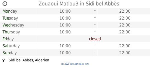
788 m
Zouaoui Matlou3
Sidi Bel Abbès
Restaurant
read more
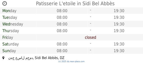
805 m
Patisserie L'etoile
نهج عسال محمد, Sidi Bel Abbès
Restaurant
read more
821 m
Play Food
Sidi Bel Abbès
Restaurant
read more
831 m
Restaurant Mon Plaisir Chez Negro
Rue Lieutenant Abdelkrim, Sidi Bel Abbès
Restaurant
read more
838 m
Mont Plaisir
26 Rue Molière, Sidi Bel Abbès
Restaurant
read more
850 m
Nice Quick (Drink And Food)
Rue Boukhari Larbi, Sidi Bel Abbès
Restaurant
read more
865 m
Patisserie La Princesse
Sidi Bel Abbès
Restaurant
read more
894 m
Sidi Bel Abbes Tea Club
Unnamed Road, Sidi Bel Abbès
Restaurant
read more
925 m
Bora Bora
Sidi Bel Abbès
Restaurant
read more
932 m
مطعم النخيل
Sidi Bel Abbès
Restaurant
read more
933 m
Adda Chahte
Sidi Bel Abbès
Restaurant
read more
935 m
Snap Food
Rue des fréres Chaabane, Sidi Bel Abbès
Restaurant
read more
968 m
Restaurant Jijeli
Sidi Bel Abbès
Restaurant
read more
971 m
la Main d'Or
Boulevard Aissat Idir, Sidi Bel Abbès
Restaurant
read more
972 m
مطعم الجيجلي
Sidi Bel Abbès
Restaurant
read more
975 m
Restauran Grillades
Sidi Bel Abbès
Restaurant
read more
975 m
مطعم السعادة
Boulevard Aissat Idir, Sidi Bel Abbès
Restaurant
read more
1.081 km
Restaurant Le Bon Coin
Boulevard Aissat Idir, Sidi Bel Abbès
Restaurant
read more
1.587 km
SNACK BomBino
Boulevard Larbi Tebessi, Sidi Bel Abbès
Restaurant
read more
1.652 km
Cadix La Maison Du Tacos
02 boulevard Mohamed KHMISTI
Restaurant
read more
2.482 km
Restaurant Di Roma
Sidi Bel Abbès
Restaurant
read more
2.602 km
Fast Food (Kebab)
Rue Belahcel Mourad, Sidi Bel Abbès
Restaurant
read more
2.641 km
Assala
Rue Belahcel Mourad, Sidi Bel Abbès
Restaurant
read more
📑
all categories
Accounting
Administrative area level 1
Airport
Amusement park
Aquarium
Art gallery
Atm
Bakery
Bank
Bar
Beauty salon
Bicycle store
Book store
Bus station
Cafe
Car dealer
Car rental
Car repair
Car wash
Cemetery
Church
City hall
Clothing store
Colloquial area
Convenience store
Courthouse
Dentist
Department store
Doctor
Electrician
Electronics store
Embassy
Establishment
Finance
Fire station
Florist
Food
Funeral home
Furniture store
Gas station
General contractor
Grocery or supermarket
Gym
Hair care
Hardware store
Health
Home goods store
Hospital
Insurance agency
Intersection
Jewelry store
Laundry
Lawyer
Library
Light rail station
Liquor store
Local government office
Locality
Lodging
Meal takeaway
Mosque
Movie rental
Movie theater
Moving company
Museum
Natural feature
Neighborhood
Night club
Painter
Park
Parking
Pet store
Pharmacy
Physiotherapist
Place of worship
Plumber
Point of interest
Police
Post office
Premise
Real estate agency
Restaurant
Roofing contractor
Route
School
Shoe store
Shopping mall
Spa
Stadium
Storage
Store
Subway station
Supermarket
Taxi stand
Train station
Transit station
Travel agency
University
Veterinary care
Zoo
administrative area level 3
sublocality level 1
↑