Hospital nearby Policlinique Cervantes
Algeria
Hospital nearby Policlinique Cervantes
Policlinique Cervantes
Boulevard Cervantes, Belouizdad, DZ Algeria
contacts phone
:
+213
Latitude:
36.7482256
, Longitude:
3.0668046
larger map & directions
read more
nearest Hospital
374 m
Dermatologue Fiko
Rue Hocine Noureddine, Algiers
Hospital
read more
457 m
CMS Rochi Boualem
Mohamed Belouizdad
Hospital
read more
645 m
Institute Pasteur, Annexe El Hamma
Rue Du Dr Laveran, Mohamed Belouizdad
Hospital
read more
646 m
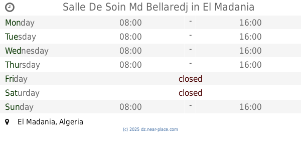
Salle De Soin Md Bellaredj
El Madania
Hospital
read more
733 m
Pasteur Institute
Rue de Tihert, Algiers
Hospital
read more
835 m
Institute Pasteur
Rue Du Dr Laveran, Mohamed Belouizdad
Hospital
read more
894 m
Clynice Saine Clair
Rue Zoubir Youcef, Algiers
Hospital
read more
924 m
Polyclunique Sidi Mhamed Bouchenfa
El Mouradia
Hospital
read more
940 m
عيادة دار البهجة
El Mouradia
Hospital
read more
943 m
مستشفى طب العيون صداقة الجزائر كوبا *الواد*
Bab El Oued
Hospital
read more
945 m
Hospital Tix Raine
Rue Tebessi Larbi, Sidi M'Hamed
Hospital
read more
980 m
Polyclinique Bouchenafa
Hospital
read more
1.004 km
Multi-service clinic
Rue Fella Mohamed Arab, Alger
Hospital
read more
1.008 km
Annexe Cpmc
Rue Frères BOUDRAA, Algiers
Hospital
read more
1.075 km
centre pierre et marie curie larbi tebessi
Rue Tebessi Larbi, Sidi M'Hamed
Hospital
read more
1.077 km
Multi-service clinic
Argel
Hospital
read more
1.088 km
Centre Diabetique
Rue Des Sports, Algiers
Hospital
read more
1.655 km
Urgence pediatrique
Bir Mourad Raïs
Hospital
read more
1.793 km
Epsp Kouba Les Annassers
Kouba
Hospital
read more
1.87 km
Service De Dermatologie
Sidi M'Hamed
Hospital
read more
1.96 km
Hopital Drid Hocine
Algiers
Hospital
read more
2.228 km
Bioplus Sidi Yahia
Tour de Bt. B, app. B2 Rdc. Route de Sidi Yahia., Hydra
Hospital
read more
2.291 km
La Next Les Glissine
90 Rue Didouche Mourad, Alger Centre
Hospital
read more
2.431 km
Surgical Clinic Sidi Yahia
Bir Mourad Raïs
Hospital
read more
2.542 km
Centre de Santé
Bir Mourad Raïs
Hospital
read more
📑
all categories
Accounting
Administrative area level 1
Airport
Amusement park
Aquarium
Art gallery
Atm
Bakery
Bank
Bar
Beauty salon
Bicycle store
Book store
Bus station
Cafe
Car dealer
Car rental
Car repair
Car wash
Cemetery
Church
City hall
Clothing store
Colloquial area
Convenience store
Courthouse
Dentist
Department store
Doctor
Electrician
Electronics store
Embassy
Establishment
Finance
Fire station
Florist
Food
Funeral home
Furniture store
Gas station
General contractor
Grocery or supermarket
Gym
Hair care
Hardware store
Health
Home goods store
Hospital
Insurance agency
Intersection
Jewelry store
Laundry
Lawyer
Library
Light rail station
Liquor store
Local government office
Locality
Lodging
Meal takeaway
Mosque
Movie rental
Movie theater
Moving company
Museum
Natural feature
Neighborhood
Night club
Painter
Park
Parking
Pet store
Pharmacy
Physiotherapist
Place of worship
Plumber
Point of interest
Police
Post office
Premise
Real estate agency
Restaurant
Roofing contractor
Route
School
Shoe store
Shopping mall
Spa
Stadium
Storage
Store
Subway station
Supermarket
Taxi stand
Train station
Transit station
Travel agency
University
Veterinary care
Zoo
administrative area level 3
sublocality level 1
↑